


'Bomb cyclone' weather threatens Metro Vancouver, B.C. coast
Weather event to remain offshore, but B.C.'s coast, mainland to see intense wind gusts as a result

Article content
A bomb cyclone was forecast for the B.C. coast, with strong winds expected Tuesday, Nov. 19 and overnight into Wednesday, Nov. 20.
A bomb cyclone is a non-tropical storm system caused by a rapid drop in atmospheric pressure at its centre.
tap here to see other videos from our team.
'Bomb cyclone' weather threatens Metro Vancouver, B.C. coast Back to video
tap here to see other videos from our team.
Recap the storm updates below. This blog is no longer being updated live.
Updates from Wednesday, Nov. 20
Additional hydro crews deployed to Vancouver Island
B.C. Hydro is continuing its work to restore power with just over 74,000 customers still waiting on Vancouver Island, the Gulf Islands, and in the Lower Mainland.
That figure is down from the 300,000 customers that were impacted on Tuesday evening.
Meanwhile, additional crews are headed to Vancouver Island to support restoration efforts. The hardest hit areas remain Nanaimo, Victoria, Duncan, Ladysmith and Port Hardy.
As of Wednesday at 11:30 a.m., the company said more than 210,000 customers had had their power restored, “however, with strong winds expected to continue today in some areas, particularly on Vancouver Island and the Sunshine Coast, further outages are expected.”
“Drought-damaged trees and branches came down on electrical equipment during the windstorm causing extensive damage,” read a statement shared earlier in the day.
“B.C. Hydro has had all available B.C. Hydro crews and contractor crews working since last night, and work will continue throughout the day.”
A number of crews were also en route to Vancouver Island Wednesday to help with the restoration efforts.
Widespread power outages also reported south of the U.S. border
The intense winds late Tuesday and early Wednesday also caused similar havoc south of the border, as the storm swept over the Northwestern U.S.
Widespread power outages were reported in Washington state, while South County Fire said on social media that a woman died Tuesday night when a large tree fell on a homeless encampment in Lynnwood.
The Seattle Fire Department also reported that a tree fell on a vehicle Tuesday, temporarily trapping a person inside, but later confirmed they were in stable condition after being extricated.
With files by The Associated Press.
B.C. Ferries cancels major morning routes
B.C. Ferries has called off most major ferry routes this morning because of the adverse weather.
The following sailings between Swartz Bay (Victoria) and Tsawwassen are cancelled:
• 7 a.m. departing Swartz Bay
• 7 a.m. departing Tsawwassen
• 9 a.m. departing Swartz Bay
• 9 a.m. departing Tsawwassen
Morning sailings between Victoria and the Gulf Islands are also cancelled, as are the morning sailings out of Horseshoe Bay:
• 6:15 a.m. leaving Departure Bay
• 8:25 a.m. leaving Horseshoe Bay
• 6:15 am leaving Horseshoe Bay
• 8:25 am leaving Departure Bay
These sailings between Tsawwassen and the Gulf Islands are also cancelled:
• 6:20 a.m. departing Long Harbour (Salt Spring Island)
• 7:10 a.m. departing Otter Bay (Pender Island)
• 7:45 a.m. departing Village Bay (Mayne Island)
• 8:20 a.m. departing Sturdies Bay (Galiano Island)
• 9:55 a.m. departing Tsawwassen
• 11 a.m. departing Sturdies Bay
• 11:35 a.m. departing Village Bay
• 12:10 p.m. Otter Bay for Long Harbour
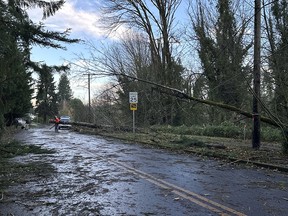
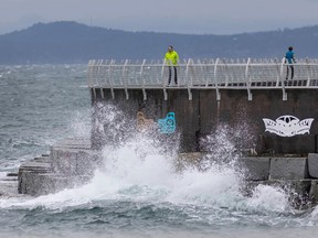
Winds batter B.C.’s South Coast overnight
Hurricane-force winds of up to 159 km/h have slammed into parts of the British Columbia Coast as a massive storm swirling off Vancouver Island severed highways and cut power to about 225,000 people.
Winds from the bomb cyclone weather system were expected to reach 120 km/h on the central and north coast, although remote Sartine Island, off the northern tip of Vancouver Island was battered by the most powerful gusts, equivalent to a Category 2 hurricane.
Winds exceeding 100 km/h were recorded in multiple areas late Tuesday, with gusts approaching 80 km/h at Vancouver’s airport.
B.C. Hydro says most of the blacked-out customers were on Vancouver Island, but there were also dozens of outages across Metro Vancouver and the Sunshine Coast.
The Transportation Ministry says multiple highways on Vancouver Island have been closed because of downed power lines, fallen trees and debris, with more closures expected as the storm moves through.
A bomb cyclone is caused by rapidly dropping atmospheric pressure at the centre of a weather system.
The Canadian Press
Updates from Tuesday, Nov. 19
Several Vancouver Island highways closed
Fallen trees and debris have forced the closure of sections of four highways on Vancouver Island. The following roads are expected to be closed until at least Wednesday morning. Highway 4 from Port Alberni to Tofino, Highway 14 west of Sooke, Highway 18 at Hillcrest and Highway 28 from Gold River to Campbell River.
Drivers across the province are being asked to stay off the roads on Tuesday night if possible.
Environment Canada issues wind warning for Metro Vancouver
A wind warning has been issued (at 8:30 p.m.) for Metro Vancouver and in particular the cities of Vancouver, Burnaby and New Westminster.
Very windy conditions are expected Tuesday night to late Wednesday with peak wind speeds expected to reach 100 km/h.
“Strong southeasterly winds will continue Wednesday morning but should ease late in the day. East-to-west inland valleys can expect very strong winds as well. Some areas can also expect heavy rain at times during this event, but winds will remain the primary concern,” the weather agency reported.
Close to 180,000 homes without power
Almost 180,000 homes are without power on Vancouver Island and the Sunshine Coast as of 8:30 p.m.
This includes all of Tofino, much of Nanaimo and much of Qualicum Beach. The bulk of the outages (95,361) are on the northern part of the island, however, over the past hour there has been a big jump in outages in the Lower Mainland (34,157).
120 km/hr winds arrive on Vancouver Island
As of 6:30 p.m. hurricane-force winds of more than 120 km/h are hitting parts of the British Columbia coast as a “bomb cyclone” develops off Vancouver Island.
Environment Canada has issued more than 50 warnings, advisories and alerts related to the storm, covering most of Vancouver Island and other coastal areas and stretching deep into the Interior.
The weather agency says the worst of the storm is expected overnight when winds in the central and north coast could peak at 120 km/h, though the remote Sartine Island was already seeing winds exceeding 130 km/h Tuesday afternoon.
Canadian Press
City of Vancouver prepares for flooding
Authorities are warning residents of low-lying parts of Vancouver to prepare for potential flooding on Wednesday as a storm surge and higher-than-normal tide are expected. These areas include Southlands, the Fraser River floodplain and Locarno and Spanish Banks area.
B.C. Ferries cancels several sailings in preparation for intense winds
B.C. Ferries has cancelled several sailings on a number of major routes on Tuesday evening in anticipation of heavy winds due to a “bomb cyclone” developing offshore.
The cancelled routes on Tuesday include:
Departure Bay (Nanaimo) and Horseshoe Bay (Vancouver)
8:45 p.m. leaving Departure Bay
10:10 p.m. leaving Horseshoe Bay
Duke Point (Nanaimo) and Tsawwassen (Vancouver)
8:15 p.m. departing Tsawwassen
8:15 p.m. departing Duke Point
10:45 p.m. departing Tsawwassen
10:45 p.m. departing Duke Point
Swartz Bay (Victoria) and Tsawwassen (Vancouver)
7 p.m. departing Tsawwassen
7 p.m. departing Swartz Bay
9 p.m. departing Tsawwassen
9 p.m. departing Swartz Bay
Horseshoe Bay (Vancouver) — Langdale (Sunshine Coast)
5:30 p.m. departing Horseshoe Bay
6:40 p.m. departing Langdale
7:50 p.m. departing Horseshoe Bay
8:55 p.m. departing Langdale
Port McNeill (Vancouver Island), Sointula (Malcolm Island) and Alert Bay (Cormorant Island)
12:20 p.m. departing Alert Bay
1:10 p.m. departing Port McNeill
1:45 p.m. departing Sointula
2:20 p.m. departing Port McNeill
NOTE: A number of sailings on this route between 3:15 to 10 p.m. on Tuesday, as well as all sailings on Wednesday are also at risk of being cancelled. Please check the B.C. Ferries website for the latest on this route.
No decisions have been made yet about Wednesday’s sailings though travellers along the Port McNeill, Sointula, and Alert Bay routes are being warned Wednesday’s sailings are at risk of being cancelled.
Environment Canada weather statements continued
Environment Canada has continued its weather statements for the Metro Vancouver region, alerting residents to the significant fall storm set to hit the coast on Tuesday afternoon.
“A rapidly deepening low pressure system will arrive approximately 400 kilometres west of Vancouver Island by late this afternoon,” said the updated alert. “This low is forecast to then curl northward on Wednesday towards the Central Coast, remaining offshore through the period.”
Residents along coastal areas can expect winds to increase throughout the afternoon, with peak wind speeds expected overnight and into Wednesday morning before easing later in the day.
Province reminds residents to prepare for potential flooding
Provincial officials are monitoring an incoming storm that will bring high winds and possible storm damage to the B.C. coast.
In a statement issued Tuesday, B.C.’s emergency management officials said they were watching for potential “shifts toward extreme wet weather,” while the transportation ministry would have maintenance contractors on standby.
“Some areas can also expect heavy rain at times during this storm, but winds will remain the primary concern,” the statement read.
British Columbians are reminded to keep their electronic devices charged, and to ensure household emergency kits are stocked. As well, officials are asking residents to keep away from river and coastal shorelines and not to attempt driving through floodwater.
Updates from Monday, Nov. 18
Forecasters issue ’bomb cyclone’ warning for B.C., with 120 km/h winds predicted
Environment Canada is warning that a “bomb cyclone” is expected to bring powerful winds to most of Vancouver Island and the B.C. coast, with hurricane-force gusts of 120 km/h predicted for some areas this week.
The weather agency has issued more than a dozen warnings for coastal areas, saying the peak wind speeds are expected Tuesday night and Wednesday morning.
Areas expected to be hit hardest include northern Vancouver Island and the north and central coasts, but gusts of up to 100 km/h are also forecast for heavily populated centres including Victoria and the Sunshine Coast.
The warnings stretch from Prince Rupert in the north to the southern tip of Vancouver Island, while Metro Vancouver and the Fraser Valley are the subject of a special weather statement.
The statement says residents should be prepared for power outages, downed trees and travel delays brought by what it calls a “significant fall storm.”
Environment Canada meteorologist Brian Proctor says a bomb cyclone is caused by a rapid drop in atmospheric pressure at the centre of a storm.
“Typically, with these bomb cyclones, we need a lot of cold air loss in the atmosphere to really eject itself into the low pressure centre, which really helps to deepen them, or helps them to explode,” he said in an interview Monday. “Typically, with this kind of storm, the key phenomena is going to be the wind associated.”
Environment Canada says the storm will develop about 400 kilometres off the coast of Vancouver Island on Tuesday, bringing high winds and heavy rain that afternoon.
Proctor said the storm will likely have the most affect the west side of Vancouver Island and the central coast.
Matt MacDonald, the lead forecaster for the B.C. Wildfire Service, says in a social media post that models show B.C. coastal inlets could bring “hurricane force” winds and there may be waves of up to nine metres off Washington and Oregon’s coasts.
Proctor said he wouldn’t be surprised to see those kinds of conditions on B.C.’s coast.
“That would be fairly typical for this kind of track,” he said in an interview.
However, he said that would depend on the track of the low pressure centre and how close to Vancouver Island it comes in before it starts “hooking” northward.
BC Ferries said in a statement Monday that it is “closely monitoring the weather situation” and is in contact with Environment Canada.
While it initially said sailings were expected to proceed as scheduled, a later statement said that it would be providing updates on Tuesday about potential delays or cancellations.
“Our goal is to keep people moving without interruption wherever possible, and to keep our passengers informed as things change,” it said. “In the event of significant disruptions, we will work to reschedule travel or reroute passengers to the next available sailing.”
Electric utility B.C. Hydro said it has been monitoring the system “very closely” since last week, noting it has a “team of in-house meteorologists that track all weather events” to ensure it has crews and equipment in the right places when storms hit.
“We’re prepared for tomorrow’s storm and are ramping up crews _ both B.C. Hydro crews and contractor crews,” it said in a statement Monday.
A La Nina winter is expected for B.C., and Proctor said the creation of bomb cyclones are amplified under those conditions, when ocean temperatures are cooler than normal.
He said the province should brace for similar storms, though not of the same magnitude.
“We’re really setting up for a fairly typical late fall, if I can put it that way, once we get past this big event of this bomb cyclone,” he said.
The bomb cyclone warnings come after a lightning storm overnight and early Monday covered parts of Metro Vancouver in hail.
B.C. has been hit by a series of powerful fall storms, including an atmospheric river that caused flash flooding in Metro Vancouver in mid-October.
The Insurance Bureau of Canada said in a news release last week that the October storm caused $110 million in insured damage claims, which prompted it to renew calls for the federal government to “fully fund” the National Flood Insurance Program.
It said insured losses related to severe weather in Canada now routinely exceed $3 billion annually and a new record has been set this year, reaching more than $7.7 billion.
The Canadian Press


Postmedia is committed to maintaining a lively but civil forum for discussion. Please keep comments relevant and respectful. Comments may take up to an hour to appear on the site. You will receive an email if there is a reply to your comment, an update to a thread you follow or if a user you follow comments. Visit our Community Guidelines for more information.